The ecological counterpart to water stress (May 1, 2018) is desertification. The table summarizing the IPCC’s assessments of five categories directly or indirectly connected to water use (April 24, 2018) refers to: “Decreasing water availability and increasing drought in mid-latitudes and semi-arid low latitudes.” The IPCC devotes long sections of its Fourth Assessment Report (AR4) to this issue (sections 3ES, 3.4.1 and 3.4.2). The IPCC predicts that the comprehensive impacts will start to be shown as we approach a 4.5oC change relative to the 1980-1999 standard. That said, desertification is already in full force and having a major global impact.
The definition of what constitutes or contributes to desertification is controversial. Wikipedia mentions the disagreement between its sources:
Desertification is a type of land degradation in which a relatively dry area of land becomes increasingly arid, typically losing its bodies of water as well as vegetation and wildlife.[2] It is caused by a variety of factors, such as through climate change (particularly the current global warming) and through the overexploitation of soil through human activity.[3] When deserts appear automatically over the natural course of a planet’s life cycle, then it can be called a natural phenomenon; however, when deserts emerge due to the rampant and unchecked depletion of nutrients in soil that are essential for it to remain arable, then a virtual “soil death” can be spoken of,[4] which traces its cause back to human overexploitation. Desertification is a significant global ecological and environmental problem.[5]
Figure 1, also taken from Wikipedia, illustrates the global distribution of vulnerability to desertification.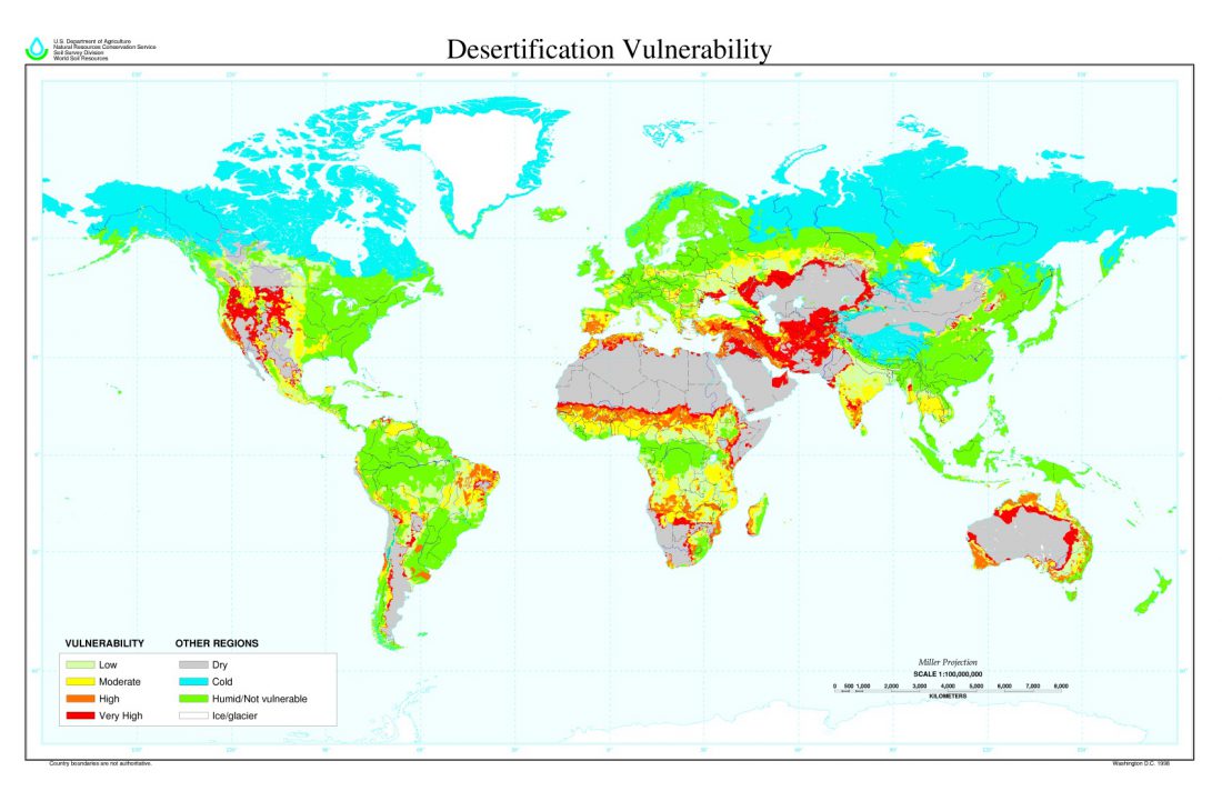 Figure 1
Desertification is a term that many scientists shy away from – both because it lacks specificity and because it comes with a bevvy of associated emotions. Figure 2 was taken by my French relative Rafik Mezouane on his recent holiday in Algiers. It’s a stereotypical picture of the implied consequences of the term.
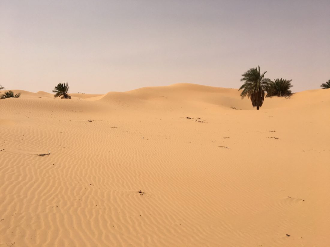
Figure 2 (taken by Mr. Rafik Mezouane) – Saharan desert landscape in Algeria
Figure 3 shows a map of the extent of the Sahara desert.
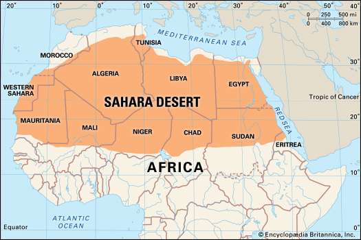 Figure 3 – Map of the span of the Sahara Desert across the African continent
There is also active discussion regarding the degree of reversibility of degraded (desertified) lands. In this case, reversibility of desertification is usually defined in terms of one generation (25 years). Of course, such a feat would be impossible with the Sahara. Nor did the enormous desert come into its status recently. The general belief is that in the past what is now known as the Sahara desert was a fertile land. Science Magazine published an interesting article a while back about the desert’s origins:
New Clue to Sahara’s Origins by Mark Sincell Jul. 9, 1999
Studies of fossilized pollen have shown grasses and shrubbery covered what is now the Sahara desert until some unknown environmental catastrophe dried up all the water, leaving nothing but sand. The exact timing is uncertain, but one interpretation of the pollen data suggests that a relatively mild arid episode between 6000 and 7000 years ago was followed by a severe 400-year drought starting 4000 years ago. Such a disaster might have driven entire civilizations out of the desert, leading them to found new societies on the banks of the Nile, the Tigris, and the Euphrates rivers. But the cause of the postulated droughts remained a mystery.
Now, climatologist Martin Claussen and co-workers at the Potsdam Institute for Climate Impact Research in Germany are proposing that the changing tilt of the Earth triggered the rapid drying of the Sahara. Like a spinning top slowly wobbling on its tip, the Earth’s tilt has decreased from 24.14 degrees to 23.45 degrees in the last 9000 years, resulting in cooler summers in the Northern Hemisphere. When Claussen introduced cooler Northern summers into a computer simulation of the Earth’s atmosphere, ocean, and vegetation, the monsoon storms that provide water to the Sahara grew weaker, killing off some of the native plants. The initial reduction in vegetation further reduced rainfall, says Claussen, starting a vicious cycle of desertification that began to accelerate about 4000 years ago. Less than 400 years later, Claussen’s team found, the drought caused by the vegetation-feedback mechanism could have wiped out almost all plant life in the desert.
One of the places most vulnerable to desertification is Africa’s Sahel region, located directly south of the Sahara and shown in deep red in Figure 1.
According to Wikipedia, the Sahel part of Africa includes:
(from west to east) parts of northern Senegal, southern Mauritania, central Mali, northern Burkina Faso, the extreme south of Algeria, Niger, the extreme north of Nigeria, central Chad, central and southern Sudan, the extreme north of South Sudan, Eritrea, Cameroon, Central African Republic and extreme north of Ethiopia.[4]
As of the 1970s, the Sahel also became a political body, albeit with a somewhat different makeup than that described above:
In 1973 the Permanent Interstates Committee for Drought Control in the Sahel (CILSS) was formed by Burkina Faso, Cape Verde, Chad, Gambia, Guinea Bissau, Mali, Mauritania, Niger and Senegal to group countries that were then becoming interdependent.
CILSS countries alone are home to around 58 million people, the majority of them subsistence farmers, sharing similar cultures and livelihoods even while their religions, languages and customs vary widely.
CILSS estimates that more than half the working-age population in the Sahel is engaged in or dependent on agriculture and is responsible for more than 40 percent of the region’s collective gross domestic product (GDP). Dryland crops such as millet, sorghum and cowpea, and cash crops such as groundnut and cotton are the predominant agricultural produce.
The population is growing very quickly in the Sahel. According to CILSS, there will be 100 million people in the region by 2020 and 200 million by 2050 – almost four times the current population. More than half of them, 141 million, will live in the three countries Egeland is visiting: Burkina Faso, Mali and Niger.
As Figure 1 shows, the region is prone to drought and desertification, meaning that it is unable to support the increasing population that subsists off of agriculture, be it herding or growing crops. So the people move elsewhere for subsistence – either they flock to cities within their own countries or they become environmental refugees in other countries. The Climate and Migration Coalition has written about this:
The Sahel region is highly dependent on agriculture for livelihoods and the wider economy. Agriculture is almost entirely rain fed, dependent upon a 3-4 month rainy season that refills lakes and the rivers which, in turn, irrigate crops. Annual rainfall is highly variable, some studies argue that the concept of ‘normal’ annual rainfall is almost meaningless in the Sahel. As well as erratic rainfall a number of other factors play an important part in creating the vulnerabilities of the people who live in the Sahel. Over the past half century a combination of land degradation, population growth and misplaced environmental and development policies have contributed to vulnerability. This vulnerability has in turn shaped patterns of migration and displacement. However, the changing climate is only one among a number of factors.
The article also includes a quote from one of the refugees:
“Migration has now become an inevitable method of adaptation for us … As a means of survival for us and our animals, we are forced to continuously migrate despite all the risks involved. This is our form of adaptation. We have always mastered it, but if nothing is done to ensure the safety of our space and activities, we risk, one day, being forced to abandon our way of life and join the swelling ranks of the unemployed in the city.”
– Hindu Oumarou Ibrahim, Peul Mbororo of Chad
In the Sahel the initiative to move is still mostly on the individual level. But we have already encountered (September 8, 2015) a different approach to a similar situation in Inner Mongolia (an autonomous region of China), where the government is forcing the Mongolian shepherds to stop herding and instead move to cities to minimize grazing and stop desertification.
Desertification, along with its causes and consequences, is a vast and complex issue. Any attempts to directly associate the phenomenon with climate change are controversial. Those of you with a desire to dig a bit deeper in this important issue might try two articles:
- “Exploring Links between Desertification and Climate Change” by Mike Hulme and Mick Kelly in Environment: Science and Policy for Sustainable Development – Vol. 35 (Issue 6), 1993.
- “Climate Change Drought and Desertification” by Henry N. Le Houérou in Journal of Arid Environments – Vol. 34, 133-185 (1996).
I had heard that the Sahara, several thousand years ago, was more than fertile land—that it was actually a forest! Also, looking at the photograph (figure 2), it is hard to believe, with all that dry sand, that the few palm trees seen could actually survive! I don’t even see any cactus plants there! So I really wonder how the few palm trees that are there could have actually survived!