Last week’s blog outlined the reasons why my wife and I decided to take our vacation in Australia. The main reason was to see family in Melbourne and a secondary reason was to try to have a short break from the weather back home. I promise that in this and in following blogs, I will go into some details.
Traveling to visit family is a common activity that many of us do whenever we have the opportunity. I think that documenting changing extended families has the long-term outcome of developing a feeling that all of us belong to the same family and thus willing to take care of each other.
For now, however, this blog will focus on the weather.
Discussing the weather requires some background. Weather and climate are the most important topics of this collection of blogs. However, I never discussed the fundamentals of the driving forces of climate in a way that would be understandable with no educational prerequisites. I will try to remedy that here with some quoted literature.
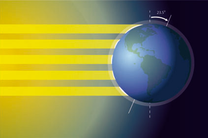
I think the best starting point is the short review by Stevens in Nature Education that references figure 1 and from which I extensively cite below. This review will serve us in this and next week’s blogs. It describes the background for choosing Darwin as an important component of our Australian vacation and it will also serve as a background for future blogs that will describe the roles that El Niño and La Niña are playing in our present climate.

Figure 1
Solar Interaction with Earth (Source: https://www.nature.com/scitable/knowledge/library/introduction-to-the-basic-drivers-of-climate-13368032/)
Sunlight Intensity Is a Key Component of Climate
Directly or indirectly, the sun provides energy for living organisms, and it drives our planet’s weather and climate patterns. Because Earth is spherical, energy from the sun does not reach all areas with equal strength. Areas that are exposed more directly to the sun’s rays (i.e., those nearest to the Equator) receive greater solar input. In contrast, those in higher latitudes receive sunlight that is spread over a larger area and that has taken a longer path through the atmosphere. As a result, these higher latitudes receive less solar energy (Figure 1).
The sunlight intensity on some parts of the earth significantly varies over the course of the year as the earth changes its orientation in space. Seasonal variation in solar input occurs because the Earth is tilted on its axis by 23.5˚ (Figure 1). As Earth orbits the sun, its orientation to the sun changes. Winter in the northern hemisphere occurs as the northern tip of the planet tilts away from the sun; during this time, the southern hemisphere receives greater solar input and experiences summer. As Earth reaches the opposing point of its orbit and the northern hemisphere becomes angled toward the sun, the seasons reverse. Tropical areas experience relatively minor changes in temperature, and their seasons are characterized by the presence or absence of rain.
Sunlight Intensity Affects Global Winds, Precipitation Patterns, and Ocean Circulation Which Are All Components of Climate
At the Equator, the Earth receives greater exposure to the sun’s rays where both air and extensive bodies of water warm under the influence of the sun. Molecules are more closely packed together when cold than they are when warm, which makes warm air and water less dense than cold air and water. This difference in relative density causes heat to rise.
The warm air that rises in the tropics is wet. Sunlight causes water to evaporate from plants, soils, and bodies of water. These water molecules rise to become part of the air; because the air is warm and less dense, there is sufficient room for water molecules within the air mass. But as the air gains altitude it cools, reducing density and space for water. The water molecules condense to form clouds and eventually fall as precipitation. At the same time as sunlight is driving evaporation and precipitation patterns, it is also creating winds. As warm air moves upward, colder air from neighboring areas rush in to fill the void left behind. Tropical air moves away from the equator and toward the poles. As it travels, it cools, becomes denser, and eventually descends around 30˚ north or south latitude. This dry air mass, having lost its moisture in the tropics, absorbs moisture from the ground, creating arid conditions at these latitudes. Some of the air is drawn back toward the equator, and some is drawn toward the pole as part of a new air mass. At latitudes around 60° north and south, the air again rises, cools and releases precipitation (though less than in the tropics). Some of the cold, dry rising air then flows to the poles, where it absorbs moisture creating the cold climates of the polar regions.
Winds are also generated by the rotation of the earth. Unlike the northern and southern direction of the winds described above, there are westward and eastward winds. These winds affect ocean currents. Warm, tropical waters carry heat pole-ward along the east coast of continents; cold water from the poles is forced toward the equator along the west coast. Warm surface currents can carry heat well away from the tropics, bringing temperate climates to areas nearer the poles than the Equator. Deeper currents are driven by a combination of Earth’s rotation and temperature differences between the tropics and the poles. Cold, dense melted water from the icecaps flows underneath warmer surface waters towards the Equator. The combination of wind and ocean currents redistributes heat and moisture across Earth’s surface. Around 60% of the solar energy that reaches the earth is redistributed around the planet by atmospheric circulation and around 40% by ocean currents.
Out of this interplay between our spherical orbiting planet, sun and oceans, global regions rise that divide the year into dry and wet periods.
For so many of us in the developed world, the seasons are defined by temperature. The freshness of spring, the heat of summer, the chill of autumn and the cold of winter. But for the billions of people on our planet that live in the tropics, the seasons are marked by the presence, and absence, of rain. The annual coming of the rains after months of drought, with the renewal of life from the giving water… And then, after months of rain and clouds, the sun reborn into blue skies as the next dry season begins. This is the domain of the tropical wet and dry climates. This is the Tropical Monsoon and the Tropical Savannah.
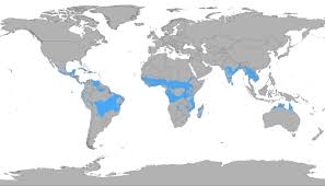
The global extent of the tropical Monsoon-Savannah wet and dry regions are shown in figure 2 with a short description below:

Figure 2
Tropical Wet and Dry Climate (Source: climatetypesforkids.com)
Tropical Wet and Dry climate is mainly found within the tropics. The tropics are two lines of latitude about 23.5 degrees north and 23.5 degrees south of the Equator. Land in this area receives direct sunlight throughout most of the year. Tropical Wet and Dry is known for its two seasons.
This band is further explained in the NOAA entry.
The Inter-Tropical Convergence Zone (ITCZ) appears as a band of clouds consisting of showers and occasional thunderstorms that encircles the globe near the equator. The solid band of clouds may extend for many hundreds of miles and is sometimes broken into smaller line segments. Its existence is due to the convergence of the trade winds: winds in the tropics that move predominantly from the east and curve towards the Equator. When the northeast trade winds from the Northern Hemisphere and the southeast winds from the Southern Hemisphere come together, it forces the air up into the atmosphere, forming the ITCZ.
The geographic extent of the ITCZ in Australia (see the previous NOAA citation) is seen in figure 2. The timing of the dry phase (Feb-March –> August-Sep) coincided with our visit. The temperature of this climate band is approximately constant (70 – 87 F (21-30C)) and the dry weather seemed to be the ideal reprieve for tourists coming from the Northern hemisphere.

Figure 3
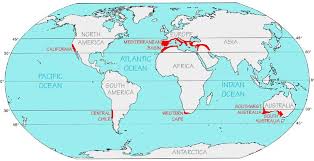
Mediterranean Climate (Source: http://www.grabovrat.com/mapsViews/mapsViewsMB00.html)
Mediterranean climate is very pleasant climate with warm, dry summers and cool, mild winters. It gets its name from the Mediterranean Sea. Most of the coastal land around the Mediterranean Sea experience this climate. This climate’s most important cause is the large bodies of water near the land around the Mediterranean and is only found along the coast.
I have some experience living with different kinds of wet/dry climate in different locations. It is known as the Mediterranean Climate. The geographic extent and short explanation of that band is shown in Figure 3. As was mentioned in earlier blogs, I grew up in Israel which is part of that climate band and did part of my early academic career at the University of California Berkeley, in the San Francisco Bay area. I remember fondly my Berkeley years (early 1970s.) and the climate there. Many were surprised that there were no conventional seasons there (at least as temperature was concerned). Often, they didn’t like it because they grew up with seasons. The remedy was that they could travel to “extreme” seasons – to mountains looking for “real” winter (snow) and to deserts for “real” summer (cactus trees and sand in the south).
However, recent changes in parts of the region that were covered by the Mediterranean Climate that historically were considered the “Cradle of Civilization” and “Birth of the Agricultural Revolution,” are now going through desertification almost unfit for human habitation. I will follow these developments in future blogs.
The next blog will expand (with some pictures) on finding the weather (and more) in Darwin. I will show that Darwin, in terms of weather, is the “Garden of Eden” for tourists in the dry season. It is something else in its wet season.

What a relatable and heartwarming perspective on travel! The decision to visit family in Australia, with the added bonus of a break from the weather back home, makes for a meaningful and enjoyable vacation. The idea of documenting changing extended families fostering a sense of belonging and care resonates deeply, emphasizing the importance of family connections. Looking forward to reading more about the experiences in Australia in the upcoming blogs!